[cs_content][cs_section parallax=”false” separator_top_type=”none” separator_top_height=”50px” separator_top_angle_point=”50″ separator_bottom_type=”none” separator_bottom_height=”50px” separator_bottom_angle_point=”50″ style=”margin: 0px;padding: 45px 0px;”][cs_row inner_container=”true” marginless_columns=”false” style=”margin: 0px auto;padding: 0px;”][cs_column fade=”false” fade_animation=”in” fade_animation_offset=”45px” fade_duration=”750″ type=”1/1″ style=”padding: 0px;”][x_image type=”none” src=”https://quay.white-shirt.ca/wp-content/uploads/2016/08/Resident-Association-Boundaries_rev-130108-orig-copy.jpg” alt=”” link=”false” href=”#” title=”” target=”” info=”none” info_place=”top” info_trigger=”hover” info_content=””][x_custom_headline level=”h3″ accent=”false”]City Reduces Quayside Catchment Area[/x_custom_headline][cs_text class=”cs-ta-justify”]For more than a decade, the Quayside Community Board believed that their boundaries extended from the edge of the Kruger Paper property on the west to the Skytrain bridge on the east. It also extended south of the rail tracks to the river. This catchment area was defined by agreement after discussions with then DRA president LILA WOOD, who stated the DRA extended only as far as the rail tracks/Front Street because “there is nothing past that point”. This understanding between RA’s was to accommodate the proposed 5 residential towers which were planned for development by Larco within the Quayside boundaries.
Recently, Quay residents’ were surprised to learn that as of 2013 City Hall did not acknowledge this agreement between neighbouring RA’s and cut these boundaries between the Quay and Downtown areas. This cut sees the Quayside east/west boundaries reduced by more than half. According to city maps (below), the eastern border of the Quay appears to stop just before the New Westminster Savings building or 10th Street. As a result, the Quay is now exclusively residential, with no businesses within its catchment. The Quay’s loss apparently has become the Downtown area’s gain.
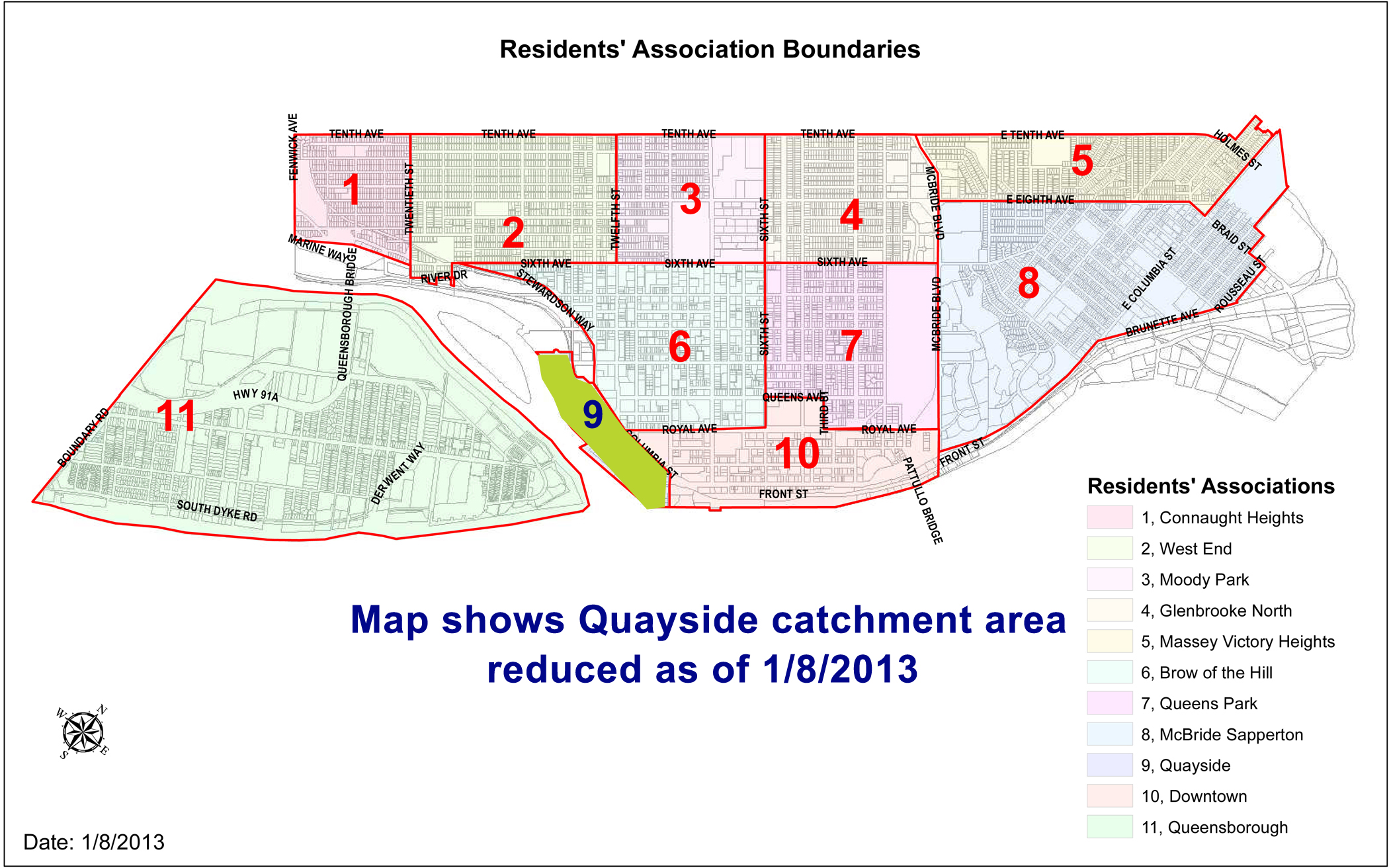
In doing research on community borders, the QCB noticed discrepancies between the official Residential Boundaries map and the some RA claims. For example, the Downtown RA (DRA) notes that their catchment area is from Royal Avenue – south to the river. Yet the official city map (above) notes that City Hall which lies north of Royal has made a concession so it is also part of the Downtown district.
[/cs_text][/cs_column][/cs_row][/cs_section][/cs_content]